Here is a slide show I found on you-tube of what these mines look like in recent years.
http://www.youtube.com/watch?v=sCc74k6bHGs
Ancestors and Copper Mining.
Are you like me and have Ancestors that came to Michigan
for work in the Copper Mines?
I went to Wikipedia to find out even more. You too can look into more about Copper
Mining. Copper Mining is still a viable business
in the USA. Read more about it.
“Copper mining in Michigan
From Wikipedia, the free
encyclopedia
Geology
Within the state of
Michigan,
copper is
found almost exclusively in the western portion of the
Upper
Peninsula, in an area known as the
Copper
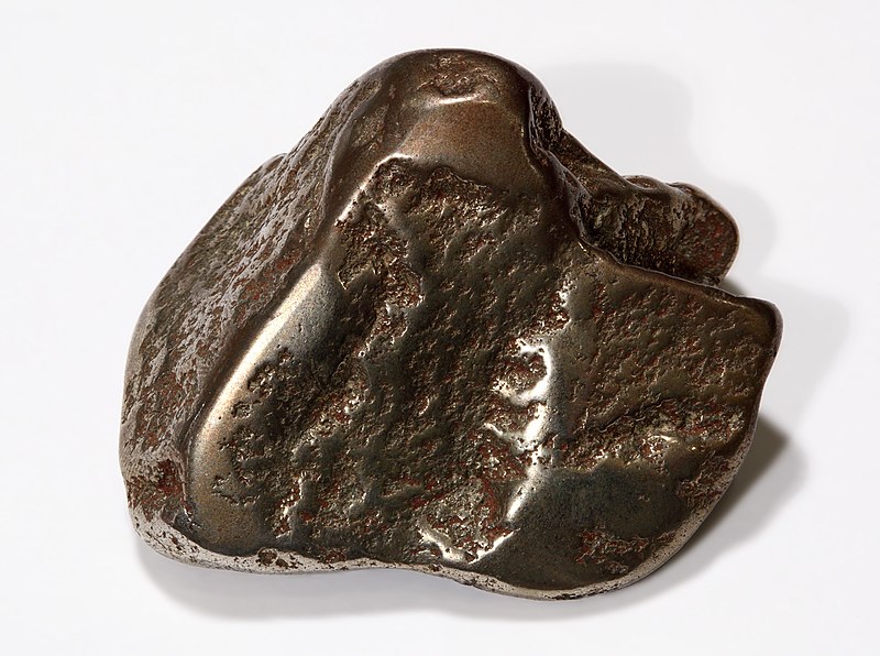
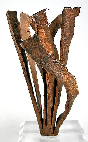
Country. The Copper Country is highly unusual among copper-mining
districts, because copper is predominantly found in the form of pure
copper metal
(
native
copper) rather than the copper oxides or copper
sulfides
that form the copper ore at almost every other copper-mining district.
Precambrian
age, in a thick sequence of northwest-dipping
sandstones,
conglomerates, ash beds, and
flood
basalts
associated with the
Keweenawan Rift.
The
copper deposits occur in rocks of
Although native copper was the dominant ore mineral,
chalcocite
(copper sulfide) was sometimes present, and, especially in the Mohawk mine,
copper arsenide minerals such as mohawkite and
domeykite.
Gangue
minerals included
calcite,
quartz,
epidote,
chlorite,
and various
zeolites.
A number of copper mines also contained a notable amount of
silver, both
in
native
form and naturally alloyed with the copper.
Halfbreed is the term for an
ore sample that contains the pure copper and pure silver in the same piece of
rock; it is only found in the native copper deposits of the Upper Peninsula of Michigan.
[1
While it
originated thousands of years earlier, copper mining in Michigan became
an important industry in the 19th and early 20th centuries. Its rise marked the
start of copper mining as a major industry in the United
States.
Native American mining
Native Americans
were the first to mine and work the copper of
Lake
Superior and the
Keweenaw Peninsula of northern
Michigan
between 5000 BCE and 1200 BCE. The natives used this copper to produce tools.
Archaeological expeditions in the Keweenaw Peninsula and
Isle
Royale revealed the existence of copper producing pits and hammering
stones which were used to work the copper.
[2]
Fringe writers have suggested that as much as 1.5 billion pounds of copper was
extracted during this period, but archaeologists consider such high figures as
"ill-constructed estimates" and that the actual figure is unknown.
[3]
By the time the first European explorers arrived, the area was the home of
the
Chippewa
people, who did not mine copper. According to Chippewa traditions, they had
much earlier supplanted the original miners. The first written account of
copper in Michigan was given by French missionary
Claude
Allouez in 1667. He noted that Indians of the
Lake
Superior region prized copper nuggets that they found there.
[4]
Indians guided missionary
Claude Dablon to the
Ontonagon
Boulder, a 1.5-ton piece of native copper along the
Ontonagon
River. When American prospectors arrived in the 1840s, pieces of
copper were found in streams or on the ground. The copper pits abandoned by
Native Americans led early miners to most of the first successful mines.
Modern mining industry
The Michigan State Geologist
Douglass
Houghton (later to become mayor of
Detroit)
reported on the copper deposits in 1841, which quickly began a rush of
prospectors. Mining took place along a belt that stretched about 100 miles
southwest to northeast through
Ontonagon,
Houghton, and
Keweenaw counties.
[5]
Isle
Royale, on the north side of
Lake
Superior, was extensively explored, and a smelter built, but no
mining of any importance took place there.
[6]
Some copper mineralization was found in Keweenawan rocks farther southwest in
Douglas County, Wisconsin, but
no successful mines were developed there.
Copper mining in the Upper Peninsula boomed, and from 1845 until 1887 (when
it was exceeded by
Butte, Montana) the
Michigan
Copper
Country was the nation's leading producer of copper. In most years
from 1850 through 1881, Michigan produced more than three-quarters of the nation's
copper, and in 1869 produced more than 95% of the country's copper.
[7]
Fissure veins
Commercial production began in 1844 at the Phoenix mine. Most early miners
began with little knowledge or planning, and few mines ever saw production,
much less profit. The first successful copper mine, the
Cliff
mine, began operations in 1845, and many others quickly followed.
These first mines worked copper-filled fissure
veins
that cut across stratigraphic layers.
Although the copper-mining region stretched about 100 miles from northeast
to southwest, the most productive early mines, working fissure veins, were
those at the north end in Keweenaw County (such as the Central, Cliff, and
Phoenix mines), or at the south end in Ontonagon County (such as the
Minesota
Mine).
In Keweenaw County, the fissure lodes were nearly vertical mineralized zones
with strike nearly perpendicular to that of the enclosing basalts and
conglomerates. In Ontanogan county, by contrast, the fissures had strikes
nearly parallel to, and dips slightly steeper than, the surrounding beds.
The miners sometimes found masses of
native
copper up to hundreds of tons. To extract a single mass of copper,
miners could spend months chiseling it into pieces small enough to hoist out of
the mine. Although they were pure copper, removing the masses took a great deal
of effort, and was sometimes not even profitable. The majority of the copper
recovered was "barrel copper" (pieces broken from the rock and hand
sorted in the "rock house," and shipped to the smelter in barrels),
and finer copper broken loose from the rock in stamp mills and separated by gravity
in "buddles" or "jigs."
Strataform deposits
Copper
mining in Michigan
In the 1850s, mining began on stratiform native copper deposits in
felsite-pebble
conglomerates and in the upper
zones of basalt lava flows (locally called
amygdaloids). Although
amygdaloid and conglomerate deposits tended to be lower-grade than the fissure
deposits, they were much larger, and could be mined much more efficiently, with
the ore blasted out, hoisted to the surface, and sent to stamp mills located at
a different site. Amygdaloid and conglomerate mining turned out to be much more
productive and profitable than fissure mining, and the majority of highly
successful mines were on amygdaloid or conglomerate lodes. The first mine to
successfully mine a strataform ore body was the
Quincy
Mine in 1856. The most productive deposit, the Calumet conglomerate,
was opened by the Calumet and Hecla mining company in 1865.
While the most successful fissure mines had been at the north and south ends
of the district, the conglomerate and amygdaloid mines, which produced the
great majority of Michigan copper, were concentrated in the center of the
district, almost all in Houghton County. The most productive conglomerate and
amygdaloid mines were located along a strip about two miles wide and 24 miles
long, from the Champion mine on the southwest to the Ahmeek mine on the
northeast, passing through the towns of
Houghton,
Hancock,
and
Calumet.
In the early 20th century, copper companies began to consolidate. With very
few exceptions, such as the
Quincy Mine at
Hancock,
the mines in the Copper Country came under the control of two companies: the
Calumet and Hecla
Mining Company north of
Portage Lake, and
Copper Range Company south of
Portage Lake.
Annual production peaked in 1916 at 266 million pounds (121,000 metric tons)
of copper. Most mines closed during the
great
depression as a result of depressed copper prices. Many mines reopened
during
World
War II, when wartime demand pushed copper prices higher. The end of
the war brought an end to high prices, and nearly all companies closed, leaving
only the Calumet and Hecla, Quincy, and Copper Range mining companies. Both
Calumet and Hecla and Quincy survived largely by reprocessing the
stamp
sand left from older mining operations, leaching out copper left by
more primitive processing techniques.
[8]
By 1968 the formerly great Calumet and Hecla was purchased by
Universal
Oil and became the company's Calumet division. By this time the
Calumet and Hecla's original conglomerate workings had been abandoned and stamp
sand reclamation had ended. The mines did not even produce enough copper to
supply the company's internal demand.
[9]
The company opened several new shafts and dewatered several old ones in hopes
of finding additional wealth, but none were successful. Later that year,
Calumet and Hecla's mine workers went out on strike, and the new owners closed
the mines for good. Only the Copper Range company's White Pine mine remained
open, and its ore was mostly copper sulfides, rather than native copper.
Michigan's native copper industry was essentially dead, after producing 11
billion pounds (5.0 million metric tons) of copper.
[10]
Several companies attempted to reopen copper mines during the next two
decades, including attempts by the
Homestake Mining Company. None
of these attempts lasted more than a couple of years or proved profitable.
Economic and environmental impact
The copper industry was, for over 100 years, the life blood of the Copper
Country. The town of Red Jacket (now
Calumet)
used a portion of its budget surplus to build
The Calumet Theatre, an
opulent opera house which hosted famous plays and acts from across the world.
Many wealthy mine managers built mansions which still line the streets of
former mining towns. Some towns which existed primarily due to copper mining
include
Calumet,
Houghton,
Hancock,
and
Ontonagon.
As the mines began to close, the Copper Country lost its major economic base.
The population declined sharply as miners, shop owners, and others supported by
the industry left the area, leaving many small ghost towns along the mineral
range.
Tourism and logging are now the major industries. The copper industry left
many abandoned mines and buildings across the Copper Country. Some of these are
now part of the
Keweenaw National
Historical Park. Some mines, such as the
Quincy
Mine and the Delaware Mine, are open as tourist attractions. Many
other mining lands are simply left abandoned.
Copper mining also took a significant impact on the environment. Mine rock
processing operations left many fields of
stamp
sand, some of which grew so large as to become hazards to navigation
in the
Keweenaw Waterway. Most of
these sterile sands are now
superfund sites which are
slowly being rehabilitated. Mines also required a great deal of wood, largely
for supports in mine tunnels. Virtually every part of the Copper Country was
cleared of timber, to the extent that only one small area of old-growth forest
(the
Estivant Pines) is left.
Formerly cleared lands have been left to regrow, to the extent that many
parcels of land are now being harvested on a limited basis by timber and paper
companies.
White Pine mine
The copper-bearing
Nonesuch Shale at the south
end of the Copper Country in
Ontonagon County had been
known since the 1800s. But the ore grades were too low, the ore mineral
particles too small, and the copper was largely in sulfides instead of native
copper. All these conditions made the shale deposits uneconomical, although
repeated attempts were made to mine the shale at the
Nonesuch
mine.
In 1955 the
Copper Range Company began
large-scale mining at the White Pine mine, near the old Nonesuch mine. The
deposit is a
stratiform deposit in the
lower 15 m of the
Proterozoic Nonesuch
Shale and the upper 2 m of the underlying Copper Harbor
Conglomerate. The principal ore mineral was
chalcocite,
although
native copper predominated in
the lower part of the beds. The mine was very successful, producing more than
1.8 million metric tons of copper during its life. The White Pine mine, the
last major copper mine in Michigan, shut down in 1995.
The company applied to government agencies to continue mining by
in-situ
leaching, using
sulfuric acid to recover an
additional 900 million pounds of copper by
SX-EW. The
Michigan Department of Environmental Quality approved the permit in May 1996,
and White Pine installed a pilot in-situ leaching project.
[1]
Native Americans of the
Bad River Indian Reservation
in northern
Wisconsin
blockaded rail shipments of sulfuric acid to the mine (see
Bad River Train Blockade);
the mine began receiving acid shipments by truck. The
U.S. Environmental
Protection Agency (EPA), which had previously held that it had no
role in the permitting, reversed itself, and stated that White Pine would have
to apply for a federal permit. White Pine, which had already started to recover
copper from the pilot project, suspended solution mining in October 1996, and
applied for to the EPA for the permit.
[2] In May
1997 the company withdrew the EPA permit application, saying that further
permitting delays had made the project uneconomical, and announced plans to
begin reclamation of the mine site.
The tailings impoundment at the White Pine Mine is presently the site of
significant environmental degradation. The University of Montana undertook
extensive efforts to restore and revegetate the barren landscape from
1997-1999, but it is unclear whether this has been successful. The university
has published a detailed report of its project.
[3]
Satellite images are available at (
46°47′17.91″N 89°31′47.97″W).
In 2012, SubTerra used the mine for pharmaceutical research.
[11]
Copper heritage
The Keweenaw Peninsula is the site of the most extensive known deposits of
native
copper
in the world. Occurring here in relatively pure form, the red metal could be
broken out of the rock and worked to make a wide variety of products, from
jewelry
and
tools
by its earliest miners to
coins and electric
wire by its
final generations. Keweenaw copper was
mined for
approximately 7,000 years, from
5000 BCE until 1968. During
the period for which records were kept, 1840–1968, more than 11 billion pounds
(5 million metric tons) of copper were mined here. During the peak production
years of
World
War I, 1916–1917, the annual copper yield reached a maximum of 270
million pounds (125,000 t).
Ethnic heritage
Two ethnic groups, the
Cornish and the
Finns,
are especially important in the heritage of the Keweenaw National Historical
Park. When news of the region's rich native copper was first widely published
in the 1830s, many families from the English county of
Cornwall
immigrated to the Upper Peninsula, bringing the
Cornish
pasty and their region's knowledge of hard-rock mining with them.
Several park Heritage Sites, including the
log
cabin village of "Old Victoria," recall Cornish heritage
in the region.
Later in the 1800s, many families from
Finland
emigrated to the United States. Until 1918, Finland was a colony of
Russia. A
large percentage of these Finns settled in the Western Upper Peninsula because
of perceived similarities between their old and new homes, and found work in
the Keweenaw.
Finnish saunas can still be
found throughout the area. Several park Heritage Sites, including the
"Hanka Homestead", recall the Finnish influx.
Calumet Unit
The Calumet Unit of the Keweenaw National Historical Park includes many
sites in and around the villages of
Calumet
and
Laurium, which are not
ghost
towns but operating human communities that have survived the
shutdown of their parent employer, the
Calumet and Hecla
Mining Company, in 1968. By digging shafts into the rock, the men
and owners of the Calumet & Hecla found geological formations of rock laced
with nuggets of almost pure copper.
The Calumet & Hecla was the richest of the separate copper mines of the
Keweenaw, and the towns built at the mine head reflect its productivity. A
1,200-seat
opera house, large
churches built of
Lake
Superior brownstone, and
mansions
built by the mining bosses survive as memories of the Calumet mine's glory
years.
Main Office of the Calumet and Hecla Mining Company
(now the Headquarters of the National Historical Park)
The Company Library and Bathhouse for its
employees.
Warehouse of the C&H Mining Company in Calumet,
Michigan.
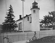
Quincy Unit
Main article: Quincy Mine
Quincy Unit, Keweenaw National Historical Park
The Quincy Unit of the Keweenaw National Historical Park
commemorates one of the most remarkable feats of engineering in northern
Michigan, the 9,000-foot (2,700 m) deep
Quincy Mine
shaft. Nicknamed "Old Reliable" for its record of paying annual
dividends for
decades, the Quincy mine enjoyed a position on the rich copper rock of the
Pewabic Lode. A private preservation foundation maintains the Quincy Mine's
surface
mine hoist, which is the largest steam-powered hoist
in the world.
Quincy Mine plan created by the HAER, National Park
Service, Department of the Interior.
Quincy Smelting Works plan created by the HAER,
National Park Service, Department of the Interior.
Mine Hoist Powerhouse for the Quincy Mine Hoist.
Heritage Sites
As of 2009, the Keweenaw National Historical Park operated in cooperation
with 16 heritage sites in the
Keweenaw Peninsula and nearby.
[3]
Adventure Mining Company
The Adventure Mining Company is located at 200 Adventure Avenue in
Greenland, Michigan.
[3]
The Adventure Mine operated in Greenland from 1850 until 1920, and consisted of
five shafts, one of which descended 1,300 feet (400 m) beneath the
surface.
[4]
Although the site seemed promising, the mine never turned a profit.
[4]
The Adventure Mining Company currently offers offers tours of the surface and
underground portions of the
Adventure
Mine.
[3]
A.E. Seaman Mineral Museum
The A.E. Seaman Mineral Museum was located on the Fifth Floor of Electrical
Resource Center at
Michigan Technological
University in
Houghton, Michigan.
[3]
As of 2011, it is now located across from the
Advanced Technology
Development Complex.
[5]
The museum is named for Arthur Edmund Seaman, who worked at Michigan Tech in
the late 19th and early 20th centuries, and was the museum's curator from
1928-1937.
[6]
The mineral collection was established in the 19th century, and by 1890
numbered 27,000 specimens.
[6]
A museum to house the collection was constructed in 1908.
[6]
The museum has since moved several times, and the collection has grown to over
30,000 specimens, of which 8000 are on display.
[7]
The museum features an extensive mineral collection and exhibits on copper
formation,
[3]
and has the world's best collection of crystallized native copper and native
copper in crystallized calcite.”
Happy Ancestor Hunting!


 The castle drawbridge and moat

 Archeological dig ongoing at
Caerlaverock
Archeological dig ongoing at
Caerlaverock


.jpg/800px-Quincy_Mine_Location_1920_(HAER).jpg)
.jpg/413px-Quincy_Smelting_Works_1920_(HAER).jpg)
